 |
| Our Lady of the River - On the Mississippi just past the confluence of the Illinois. |
 |
| Inside one of the two locks we went through on the Upper Mississippi. We're in there with a larger trawler called Paradise, and a smaller "vessel" called Caught You Lookin. |

There are, of course, several major differences between this trip and the last, without even mentioning the duration. And, what also makes this trip down this river different from other river trips, is the absolute lack of services or marinas for so many miles. Certainly help is available if you need it. But, it will be a long wait in a rather inhospitable environment.

You really begin to notice that you are not in Kansas anymore, so to speak, when you sizzle past the confluence of the Mississippi and the Illinois Rivers. You actually pick up quite a bit of speed depending, of course, on the water level and the river stage. We are experiencing somewhat of a lower stage and lower water than has been the norm this year. While we still have plenty of water under the boat, you can see that the water levels have been much higher. One clue is the bollards at any dock you see along the river banks. The bollards tower 30+ feet high over the surface of the water. In other words, the docks attached on floats to the bollards can be as much as 30+ feet higher. This would mean that the river would seem much wider and certainly, much deeper. I would expect that in some cases, the trees you see on the banks now might very well be completely submerged at a higher stage. Also, the fact that many of the houses that bank the river are on stilts and set back quite a way from today's river bank.

With higher water, comes higher speed of flow. Now, we are experiencing a down-bound current speed boost of 3-4 knots. This means that, at the rpm setting I would normally use and achieve 6.8 knots, we are travelling at 9.8 to 10 knots, and sometimes a little more. What this means, among other things, is a huge savings in fuel. I can travel many more miles and not consume any more fuel. Nevertheless, as many of you land lubbers might not understand, things happen faster at higher speeds. So, you are probably thinking to yourself, how much excitement can you really generate at 11.2 mph? Remember, that you are not in a 6000 lb car moving 65 on a flat, paved road with lanes. We are moving down a curvy river in a 52,000 lb boat with a single propeller, a full keel, and no brakes. Trust me, things happen faster. Also, just because you turn around, doesn't mean you are not still moving down river. Unless you really power up, you might as well be a dead log floating down in the current. Speaking of dead logs, now, unlike cruising on the Mississippi, there's something you don't see coming at you on too many of America's highways and byways.
 |
| Standing waves.....surfable. |


So, the idea is that you can generally poke your nose in behind one of these wing dams and drop a hook. Thus, you would be anchored out of the channel, and in an area where the river current might not be so dramatic. Unfortunately, the area behind these wing dams can get very shallow very fast. It is important to keep in mind that the water level on the Mississippi can fluctuate up to 3 or more feet per day. This is important to keep in mind if you anchor in 6 feet of water. Moreover, you might go over a sand hump that is 5 feet deep into a deep spot with 10+ feet of water. If the water level drops 3 feet over night, you better have a shovel as you are not going to get out of the pool. It's a lot to keep in mind.
The other thing these bank and submerged wing dams create is turbulence in the bends. The water can go from quite flat to quite violent in a very short period of time and then back to flat again. We have seen whirlpools that were 20 feet across and 3 feet deep in water that is close to 50 feet deep. Think of these as really big pot holes. It's almost a good thing they are that big so they are easy to see. My practice is to take the boat out of auto pilot and rest my hand on the throttle. When you cross these, certainly the momentum of a boat this size and its ultimate inertia through the water helps. Generally, there is a sensation like the back of the boat is spinning out. It's like losing traction with your back wheels when on an icy road and the back end of the car goes forward of the front end. As I said, given the boat's size, weight and inertia, we merely sense these whirlpools as a minor spin out and keep going. Nevertheless, it gets your heart a beatin' when you encounter these for the first time.
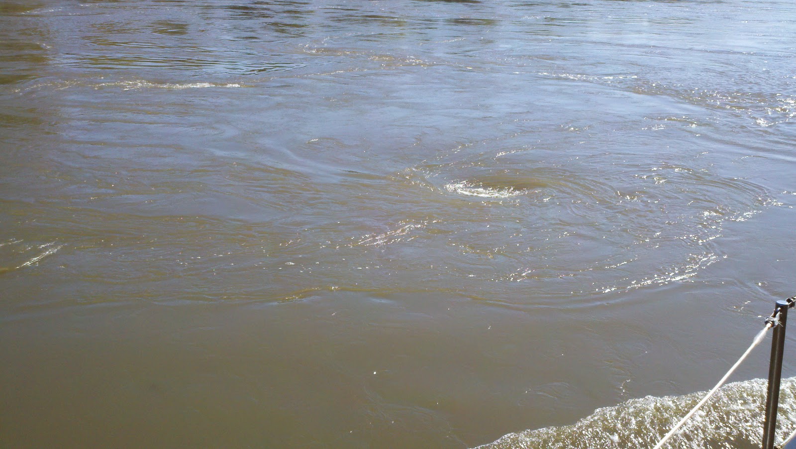 |
| Nice little whirlpool. |
 |
| 34 Loads. That's a big one. |
I have spoken of AIS before so I will not repeat myself, but if you do not have it, then you are taking a lot of risk running the Western River System. Also, you are missing out on the nice conversations you have with the tow captains. You see, they are much more likely to talk to you when you call them by name, as opposed to, "Calling that northbound tow at mile marker 145, this is".......and thus and so. I had one guy the other day engaged in a conversation about our boat and our cruise. He asked us where we were heading and I told him the Gulf. He asked if we were going to take the Tennessee River. I told him, of course we were. He then made some funny crack about the bull skull on the front of the boat and then offered us the name of his aunt who has a fuel dock on the Tennessee River; he told us to mention his name and she'd give us a discount on our fuel. No shit!
Well, the scenery thus far has been nothing short of spectacular. We are seeing the changing colors of fall, bald eagles, golden eagles, heron, gulls, and even white pelican. Population centers are rather sparse south of St. Louis, and there are no places to stop once you pass Hoppies until you get much further down the line. Speaking of Hoppies......
We stopped at Hoppies Marine Services at mile marker 158.5, not because we needed fuel, not because we needed water, not because we needed anything. We stopped there because we wanted to meet Fern and "Hoppy". For generations, Mr. Hopper's family were lamp lighters on the Mississippi. They tended the lighthouses and the lighted aids to navigation. Mr. Hopper is the last one left. He and his wife, Fern, have had Hoppies Marine Services there at mile marker 58.5 since 1934. The facility consists of little more than several barges tied together and secured to the river bank. There is a fuel dock and a place to get water or other marine services. It is right under the riverside town of Kimmswick, Missouri. We didn't take the opportunity to visit the town, but we understand that the majority of the homes there have been designated historic landmarks on the National Registry of Historic Places. Again, the real reason we came to Hoppies was to meet Fern.

Fern is in her mid 80's but you wouldn't know it by watching how she drives her golf cart up and down the docks and handles the lines of boats coming in for fuel or for the night. She has been running boats up and down the river all her life and few people have more knowledge of what's going on between St. Louis and Mobile, Alabama than her. Each afternoon, at between 4:00 and 4:30, Fern "holds court" so to speak, and puts on a short seminar for the boaters who want to attend. There is a party shed at the end of the dock where we all went for Fern's seminar. Actually, there were only 4 of us there, but it did not matter. We learned about the stages of the Mississippi River, the currents, the anchorages, recognition of physical signs on the river that meant trouble or safety, as well as the status of lock operations on the Ohio, the Cumberland, the Tennessee, and the Tombigsby. She also answered any questions anyone had. Fern has a delightful smile and a wonderful warmth. She let's you know you can call her any time you have a question. I might just do that. I might also give her a call at some point just to say hello and to let her know we made it safely. I'm sure she'd appreciate that. She give so much and asks nothing in return.
 |
| Pastoral anchorage at Rockwell Island. |
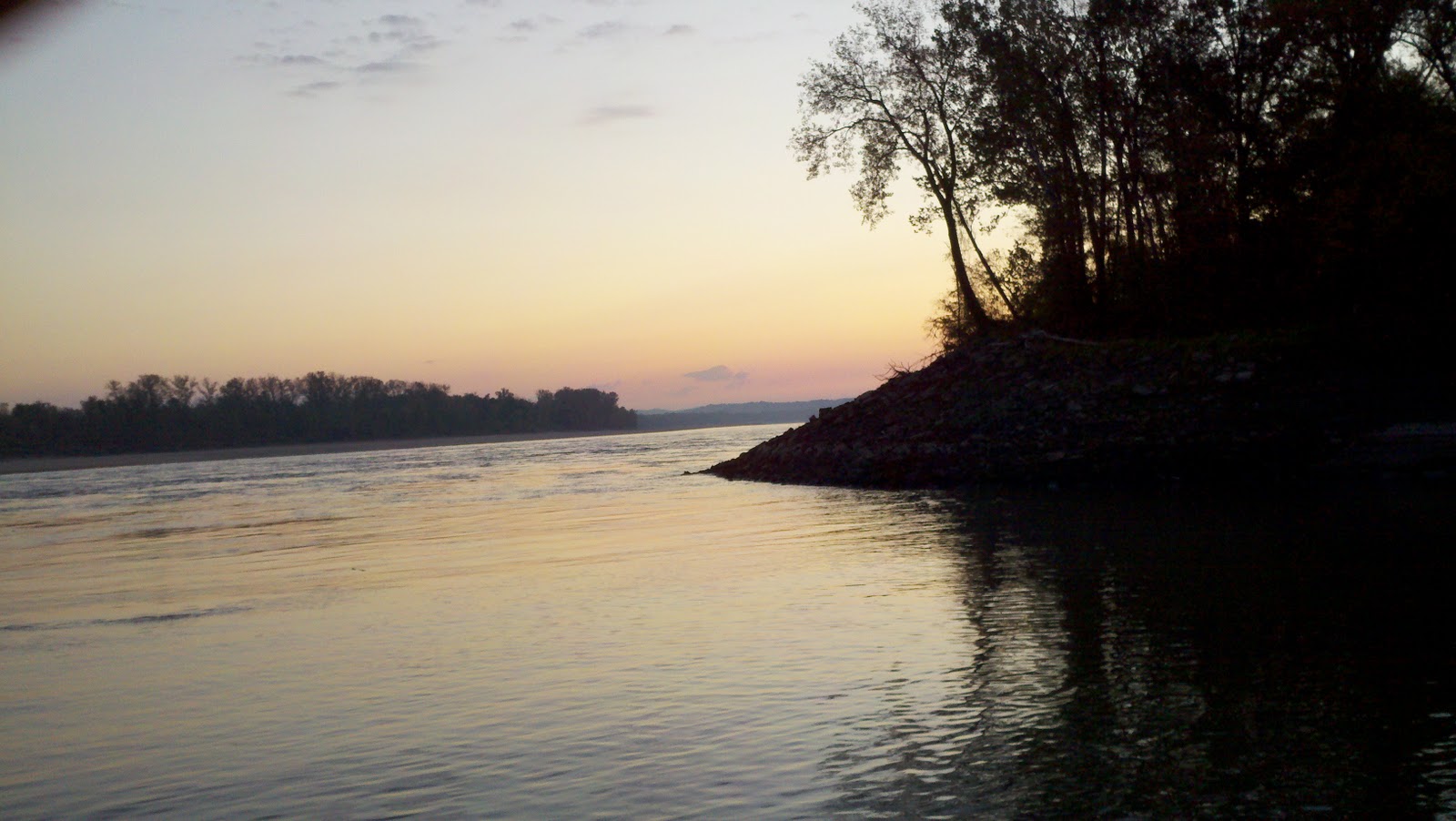
We stayed only the one night at Hoppies and then continued down the Mississippi and anchored for the night at a place called Rockwell Island. It's at mile marker 102.4. This means that there are 102.4 miles left on the Upper Mississippi. Then, the mile markers will start over for the middle and then lower Mississippi. We, however, will be turning off the Mississippi at MM 0 and will be then heading up the Ohio River for several miles before merging onto the Cumberland on our way to Nashville. We have a few more days to get there, however, so stay tuned.
 |
| Sunset at Rockwell Island |

Today was a most frustrating day. It seems like every time we met with a barge, we happened to be going into a narrow area that was very turbulent. It seemed like every time we were going into a turbulent area, it got narrow and there was a barge coming. It seemed like every time there was a narrow area, it was turbulent and there was a barge coming. Finally, it seemed like every time we went into a narrow and turbulent area with a barge coming, there was a dead tree floating nearby on the surface. This went on and on all day long. It's just the way it is. It was exhausting.
I have said before that most, if not all of the guys driving the pushers are pretty personable and generally quite helpful and easy to deal with on the radio. Today, we cam across the first exception to this generally understood rule.

We were coming into an area which Fern had outlined for us as one of the most turbulent. It is near mile marker 84 and involves a pretty narrow area, a deep turn to the right, and lots of weir dams under the surface. We were warned. So, of course, as we were approaching this turn, I noticed on the AIS screen that there was a barge coming. I called him on the radio. Here I am thinking to myself, OK, I'll be a nice guy and ask him if he wants me to hold up before the bend. He was pushing a really big load. Had to be close to 30. His response was, (emphasize in your heaviest heavy southern drawl) "Just a keep on a comin', unless you don't know how to draaav. Wun whistle." Suffice it to say, his response was not what I was expecting. Perhaps it was just his tone. I was tempted to make some kind of wise crack about seeing whether or not this backwoods redneck thought he could "dravv" the traffic on the 710 between the 405 and PCH in Los Angeles at rush hour. Then it occurred to me that it would not be a good idea. So, I held up anyways, let him come out of the turn, and then passed him on the one. OK, so we didn't wave at him as he went by. That'll show him! Ha! Oh never mind.
One narrow, turbulent, barge ridden, debris laden turn after another. All day long. I'm glad we only have 49 miles left on the Mississippi. The current is quite swift in some of these turns. We have seen speeds of up to 12 knots in some of them. Combined with the turbulence, it makes for an exciting ride. Then, lay in a 1000 footer also making the turn, sharing the narrow space, with flanking engines on full, pushing a 4 foot wave out the side, and putting you in the more turbulent water off the sailing line and you have excitement. You might think I am complaining. I'm not......really. It's just that running through these turns in a 30 year old boat, with a single, rather low horsepower engine can get your blood pumping; not because of anything that happened, but knowing what could happen. It probably doesn't occur to most folks that driving a slow trawler on the Mississippi River could be characterized as an "adrenaline sport" not unlike, perhaps.......... bungee jumping or base wreck diving. I suppose that, not unlike the aforementioned, it's only a real rush the first time. If I ever come down the Mississippi again, I'm certain it won't be nearly as exciting. But who knows?

We are anchored for the night in a what is called a "river discharge canal." What are they discharging? I have no idea. I'm not planning on swimming in any event. It's narrow and tree lined. In some places and under some circumstances, this would be a pretty good place to weather a storm. It is about 8 feet deep and less than 200 feet wide. There are tall trees on either side. I have no idea where it goes, but it is identified as one of about 3 anchorages on the Mississippi between St.Louis and the Cairo/Ohio River confluence. So, here we are. Two hooks out, and all's well.
There is one other boat also in here. Funny. This guy passed me early in the morning and was running at around 20 knots. We show up at around 3:30 in the afternoon and there he is. Well, I'm all but certain he used a hell of a lot more fuel getting to the same place. It's kind of like the story of the turtle and the hare. However, when we anchored, he and his partner were well into the football games. Their boat has satellite TV and they were watching the Packers game on the plasma screen while sitting outside on the enclosed back deck.
There is also a tow boat (a pusher) sharing the anchorage with us. They don't use anchors. They simply drive the front of the boat up into the bank and keep the appropriate engines engaged in forward gear. They don't move. They sure do make a lot of noise, however. It's quite a bit more loud than your average commercial fishing boat sharing an anchorage with its generator running all night.

It's really cool watching the river flow by outside the mouth of this canal. You get the impression it is moving very swiftly. Barges going by downriver have their engines in full reverse while making this bend. Barges going up river move very slowly at full power heading into the current and into the turn. We saw a small open fishing boat with an outboard motor go skipping by. I thought to myself, "this guy's crazy." Then he starts making a turn and pulls right into this canal. He sure made that look easy. I suspect he does it all the time.
Well, that's all for now. One more day and one more night on the Mississippi and then onto the Ohio.

More later.
Our last day on the Mississippi was great. There was plenty of sunshine and it was nice and warm. The river sections we ran down this day were somewhat wider and less turbulent. There was plenty of barge traffic, but under the circumstances, it was quite manageable.


On the water, we have rules concerning priority of movement. And where it stands to reason that these big boats and barge loads always have priority, I am hearkened to my days involved in an admiralty case when I learned of a US Supreme Court Case that held, in any collision case, liability is always apportionable. I bring this up because of a story I heard recently of a 43 foot DeFever which got into a little scuffle with the wake of a barge and ended up rolled and sunk. 5 hands went into the water. Nobody got killed, fortunately. Anyways, there is nothing but speculation going on out there concerning the cause of this mishap.
 |
| Photographs do not adequately depict the violence behind the towboat. |
 |
| The towboat will leave a standing wave in the river you could surf on a long board. |

It just goes to emphasize how important it is to be completely aware of your surroundings, completely prepared for what may be coming at you around a corner and, to have a seaworthy vessel. There is speculation that the barge could have (but didn't) placed a man up on the nose of the furthest out container to enable the skipper to see around the corner, so to speak. Most recreational vessels do not have the broadcasting type of AIS. This would have enabled the captain of the tow boat to, perhaps, call the DeFever on the radio and suggest he hold up. Well, that would be a strike against the tow boat, wouldn't it........the need for a proper look out, and all.
In any event, it's all rampant speculation and everyone seems to have an opinion. There will be an outcome someday. If and when it happens, and if and when we hear of it, perhaps I'll post it so we can all learn from it.
So, today, we will be heading up the Ohio River towards its intersection with the Cumberland River and then points beyond.

Take care y'all and we'll see you on that one whistle.
No comments:
Post a Comment