 |
| As you can see, the colors are changing. This is running down the last part of the Illinois River. |
My parents met a guy named Don over fifty years ago when dad was stationed in Alaska during his short stint as an Air Force Officer. Well, Don lives in the St. Louis area. I guess I had mentioned to my mom that our course would take us onto the Mississippi River (again) and she suggested a stop in St. Louis and a visit with Don. At first, we were hesitant because the cruising guides said there is no place in St. Louis to stop. Not really, anyway. However, we later learned that there are a few places (4), two above St. Louis, and two below St. Louis, from which we could visit St. Louis. In both cases, however, we would have to take a place in a marina and rent a car, both of which take money.
 |
| Here we are approaching the confluence of the Mississippi and the Illinois Rivers. |
Much to our pleasant surprise, however, we found this place, Port Charles Harbor, just a couple miles UP the Mississippi from the confluence of the Mississippi and the Illinois rivers. When I called, I asked whether or not it was easy to get to St. Louis from there. The nice gal on the phone told me that they have a courtesy van we could take. She told us that the only caveat was that, if there were other transient boaters who also wanted to use it, we would have to share it, but that, at present, we were the only ones coming, so the car was ours. So, we would have what we needed to go to St. Louis and visit Don and do some other sightseeing things while there. Of course we would like to see the Gateway Arch, and maybe even visit something related to Budweiser.


In the interim, we stopped for a night at an anchorage near the town of Valley City, Illinois where there is absolutely nothing. We anchored off the main channel near a bridge. This location was strategically selected insofar as it would protect us from the movement of 1000 foot barges that ply the rivers all day and all night. You truly have to pick your anchor spots carefully. If you are anchoring in a bend, for instance, you best be on the correct side so that when the barges go into or come out of a turn, you are not where they need to go. Anchoring in a straight away is a good idea if the river is wide enough. The key is to light up the boat like an oil platform at night so you can be easily seen. Certainly the towboats have radar. They also have these enormous spotlights (generally at least 2) that they have turned on when running at night that light up the river ahead of them like day. So, when they come down the line, you know it because, when the spot lights hit you, the inside of the boat is lit up like you cannot believe. Then, when they pass you, it sounds like a 747 taxiing by on a runway. I never feel comfortable anchoring out in the open like that.
 |
| The small town of Grafton which lies right at the confluence. |
 |
| The confluence. To the far side of the sand bar is the Mississippi River. |

Since we were able to stretch it a few extra miles the day before, and since we were able to get through the last of the Illinois River locks without any delay whatsoever, we didn't have quite as far to travel to our next stop which was at least tentatively planned to be at the end of the Illinois River or the beginning of the middle of the Mississippi (technically, the upper Mississippi for the next 218 miles). We'd thought about Grafton and we'd thought about Alton. But, we discovered St. Charles. And, after talking with the nice folks there on the phone, we decided to go there.
 |
| Now we are headed up the Mississippi - towards St. Charles |
Add to this that before we got to make landfall at Port St. Charles, we had to merge from the Illinois River to the Mississippi River. You read all this "muckety muck" about the currents and the turbulence at the confluence of major rivers. And, they're not kidding. Then, my AIS is telling me there is quite a bit of barge traffic that will be hitting the intersection at about the same time we will be. Then, there are aids to navigation all over the place and they are of all different shapes, colors and sizes. Then, we are starting to pick up speed. Then, we are not only merging onto the Mississippi, but we are supposed to turn right and actually head up river! Here's where it gets interesting.
 |
| Old Town St. Charles |
 |
| A statue of Lewis and Clark, and their dog, Seaman, facing west. |
Brenda wanted to drive the merge onto the Mississippi this time, since I drove it the last time when we shot out of the Harvey Lock onto the Mississippi down in New Orleans. I said, OK, and was tasked with taking pictures. So, I'm out on the bow and we are getting very close to turning right. We have to clear a charted submerged wing dam before we can do so, and there is this damn sand island out there that is not on the Army Corps of Engineers Charts. (as an aside, the ACOE Charts haven't been updated in more years than I like to think about.....I think it's been since the 80's) Then, as we are making the turn, Brenda calls me back to the wheelhouse and points to the chart plotter laptop and the screen is all black. What happened to the damn charts?!!!!

So, now we are essentially blind heading up the mighty Mississippi! Well, not completely blind. We could see the aids to navigation which, by now, had settled into a steady red-green thing as we are now heading up the Mississippi. You don't need to be a genius to know that the reds are on the right when you are going UP river. You just have to remember it. We did. No problem there. The channel was plenty wide and deep. The current turned out to be almost a non issue as we did not even change our throttle settings from when we were going down river on the Illinois, and we only lost a knot of speed. (We obviously slowed significantly when our chart plotter went blank on us while we got oriented with the paper charts. But shortly thereafter, we were right back up to the rpm level we started at.) Moreover, we had our paper charts and many, many years of experience using charts. The thing is that ACOE charts are not like NOAA charts. They look quite different and do not have as much information. They lack little things like..... WATER DEPTH! (I'm sure you can hear me screaming). And the aids to navigation are not numbered, so it is very hard to identify where you are on the chart. There are certain fixed marks that have the mile markers on them, but sometimes they are not immediately apparent as they are far away tacked to an overgrown tree on the river bank. Having identifiable aids to navigation at this point was mission critical since the way to this place we were going required us to pass between two islands in what one cruising guide described as a "Deep Channel" from the Mississippi River proper into the Dardene Slough. Slough? Well, yes. So we shifted quickly into paper chart mode and started locating landmarks.

I'll tell you a little secret. Many smart phones such as the Android have a navigator application which will pinpoint your location on the globe and then show you where you are on a satellite photo basis. I had done this previously so I could at least have a visual image in my mind of what the environs looked like before we got there. Always a good thing to do, I think. So, I had the Droid on Navigator Mode and we had the paper charts. What a difference that makes to be able to see where you are from a bird's eye view while you are trying to pick out landmarks on the ACOE charts. It helps bust the boulders in your gut down to manageable size river stones.
 |
| An old train depot - built during the great westward expansion, lots of folks passed through here on their way west to find fame, fortune, and what have you. |

So, here we are, docked at the Port Charles Harbor. Interesting and pleasant. We had lots of water under the boat until we got through the outer jetties. Once in the harbor, we have barely 4 feet of water under the boat. It's probably deeper, but the silt in the water makes it seem shallower. I believe I have discovered the trick to entering harbors. TURN OFF THE DEPTH SOUNDER! It will only make you crazy and sick. If you cannot bring yourself to turning if off, try not to look at it. So long as you are still moving forward, you are not stuck in the mud, and that is a good sign. The cruising guide said there should be a lot more water than this, but another cruising guide also suggested that the water levels on Mississippi can change as much as 4-5 feet over night. This is definitely something to think about if you are anchored in 6 feet of water......11 or 1. What's it going to be? He he he he he he. Just another stomach boulder. No big deal.

In any event, once we got tied up, we went up to the office to check in and were met by the most pleasant folks who handed us our "transient package" complete with maps, written directions, lists of things to do and see, and then, the piece de resistance - as we were walking out the front door, Linda pulls up in a mini van and says, "I just had it washed and it's all gassed up, so have fun!" With that, she tossed me the keys and went back into her office. Holy Cow! I have once again been reminded that there is often no end to the lengths folks will go to extend hospitality to travelers. I suppose folks do it for a lot of reasons. However, there are places like this where it is obvious that they do it because it is just the kind of folks they are, deep down inside. It makes me proud to be part of this race called "Human".
It's clearly not all bad out there. Folks like these restore my hope. We've experienced kindness and generosity almost everywhere we have been - from the smallest little villages like Presque Isle, Michigan and Havana, Illinois, to the largest cities, like New York, Miami, and Philadelphia. And, even in the worst economic times our country has seen since the 1930's, folks are still generous with their kindness and with their willingness to be friendly and accommodating. With all due respect to my friends who experienced the depression in the 1930's, I think it is a lot worse now. I think that, unlike the 1930's, we live in a much more complex society where, among countless other social ills, "approprietness" is all but lost, and solidarity is overshadowed by a sense of entitlement. Oh well. All I'm saying is that there is still a lot of good in this place we call home. America. She's simply too big not to surprise you every time you turn around.
More later.
So we took the complimentary courtesy car out for a spin. We visited St. Charles. This is a very nice community. The old part is very cool as it emphasizes the history of the area. You have to pull out a map to see where we are to understand. St. Louis has its Gateway Arch. It is called the Gateway Arch because this area was considered the gateway of western expansion. This area, and especially the town of St. Charles, celebrates the expedition of Louis and Clark. Additionally, St. Charles served as the territorial capitol of Missouri and was the first state capitol from 1821 to 1826. St. Charles grew over the years as a result of the western expansion as well as immigration.

The streets are made of brick and the buildings in the old part of St.Charles are made of brick, stone or wood. They all seem to have the old style leaded glass windows and house a plethora of shops carrying all kinds of goods, mostly souvenirs and other "kitch" items such as kettle corn, scent stuff, christmas ornaments, and other things you might display on shelves or mantles. The newer part of St. Charles is a very modern town with everything from Cabellas to West Marine.

We spent a couple days walking up and down the streets and it is there that we met Don and Sue for lunch. Don and my folks met a long time ago when they were all Air Force Officers stationed in Alaska during the Korean War. Don showed up with a couple old photographs of my parents at least several years before they were my parents. I couldn't help but be amazed that, when these pictures were taken, my father was only 28 years old. It's funny how you never think of your parents having once been younger than you are now. It was great seeing Don. He reminded me that it has probably been more than 25 years since I had last seen him. I am glad my mom continues to keep in touch with Don. As I told him when we parted company, I hope to keep in touch with him regularly as he is, in fact, practically family.

While in St. Charles, we also visited the Lewis and Clark exhibit. This is a collection of all the artifacts used when the Discovery Channel sponsored a 200 year celebration by outfitting a team and sending them off to re-trace the footsteps of Lewis and Clark for a film crew. There are replicas of the keel boat used to transport their gear. There are replicas of the log canoes they made with hand axes. Their clothing, equipment, writings, drawings, and other items of personal consumption are all on display. You can certainly spend an entire day or more in this place reading all there is to read. One thing it is very important to understand is that this adventure took place almost immediately after the completion of the Louisiana Purchase transaction put together by Thomas Jefferson. There were folks in Congress at the time who thought Jefferson did nothing but purchase a vast desert. This expedition proved all the detractors wrong. Lewis and Clark wrote amazing digests filled with accounts of hundreds of new species of flora and fauna, as well as great new charts of the regions they passed through. With the help of their indian friend Sagagewea, they managed to meet and greet thousands of other indians. Notably, they only lost one man during the entire voyage. Needless to say, it must have been quite a trip and its impact on the future of this country is still being felt. The results were railroads going west, and settlers moving west, all towards that jewell called the Pacific Ocean. The rest is, as they say, history.
.

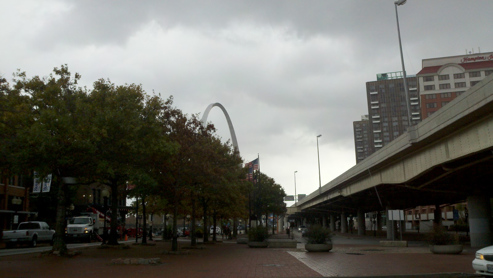
We also had a chance to go to St. Louis and visit the famous Gateway Arch. Not only did we visit it, we had a chance to go to the top. It is a lot bigger than it looks in photos. It's over 600 feet tall at the center and is surrounded by a beautiful park. It sits near and overlooking the area where the first bridge went over the Mississippi. Designed by Finnish architect Eero Saarinen, it is definitely symbolic of the role of St. Louis as the Gateway to the West.

When you go up, you ride in these "train cars" that resemble sections of a bicycle chain I suspect are referred to as capsules. They stuff 5 people at a time into each capsule. There are trains going up both the north and south arch sections. The ride up takes about 4 minutes. We rode up with these three young ladies who were part of a larger group of young people from a smaller town near McAllister, Oklahoma who were all in St. Louis visiting the arch on their way to Indianapolis to participate in a FFA Convention. FFA stands for Future Farmers of America. This is the extension of the 4H Group for kids who are in highschool. One of these girls raises show pigs. The other raises goats. And the third raises various permutation of cattle (I can never get them all straight, though I understand a big part of the description depends on whether or not they have horns or balls.)
 |
| This is the "capsule" you ride in to the top of the arch. |
Then, we went over to the Anheiser-Bush plant hoping to get a tour. Alas, we missed the last tour by less than a quarter hour. We're not feeling too bad about it, though. We have heard that, since the company was bought by a Belgian interest several years ago, the tour is not quite what it used to be. I mean, they charge $25 per head for the tour and I saw nobody walking out with cases beer or anything. In any event, we walked around the visitors center and learned what we could from the placards on the walls which basically described and showed pictures of everything we would have seen on the tour in any event.

Since we didn't get to sample any Budweiser at the factory, we decided to head back into the city and find a pub and do so on our own terms. So we did. We found a place to park in the old part of St. Louis and walked to this place called Big Daddy's, a short distance from the Busch Stadium where, it just so happens, the Cardinals were playing the Rangers in game 1 of the World Series. I guess because so many folks were at or near the game, we had the place almost all to ourselves. I am pretty certain that when the game was over, this place was packed. However, while it was going on, we were pretty much on our own and the streets were pretty quiet.

So, there we sat drinking Budweiser and eating some decent finger foods. Brenda actually drank a beer. Well, she drank half of one and then switched back to wine. I got to finish hers. Not a problem. It was kind of funny seeing a "Coors Light" banner hanging from the balcony at another local pub. I was thinking to myself that, in this city, flying such a banner would be almost like flying a Red Sox flag in New York. basically, unless you are prepared to defend yourself this kind of thing simply is not done.

So, we added another crewman. His name is Buddy. Well, actually, it's Big Buddy. He is an indoor propane heater. This studd carries two propane tanks, one under each arm, and belches out heat quite efficiently. He has all sorts of sensors so the maker says it's safe for indoor use. We would only bust out the Budster if we are anchored out and it gets really cold. In that regard, it's starting to get pretty cold from time to time. We had it down to the high 30's last night. We'll enjoy having Big Buddy aboard for sure. He will be more expensive to feed than Hairy, Olga, Henna, or Steutel. Nevertheless, I think he'll earn is keep this winter.


 |
| That's Brenda sippin' on a Bud. |
No comments:
Post a Comment