After we left Tommy and Coral’s dock, we had a most pleasant evening in an anchorage inside Miami, protected on three sides by the causeway, Pelican Island, and another island I cannot recall the name of. All afternoon, however, tourist boats would pass through there and other boats would also come in and drift for a while. I think you could also call this area “Lover’s Lane”. We took notice of one blue speed boat with a paint job like a blue 66 Corvette (yeah, it had lots of chrome, too) that came in and cut its loud engines. First the driver and his girl were making out and then she seemingly disappeared while he sat on the bench. Now, that was a little too obvious, but hey, it’s Miami, right? Then they both disappeared down into the cabin. Every 20 minutes or so, he would stick his head out of the hatch to see where they had drifted. No anchor on this boat.
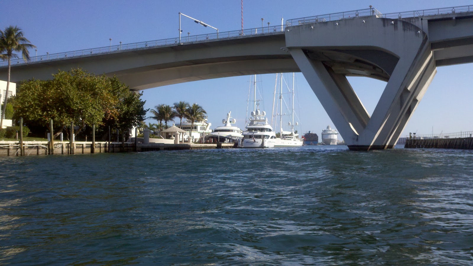
That evening, each of the 5 cruise ships that were in the Cut departed. The cut is pretty wide, but not that wide. It is wide enough, however, for two ships to pass each other. All I can say after witnessing this is that the pilots earned their dineros that day. It was fun to watch as all the passengers lined up under the lifeboats for the traditional muster drills conducted prior to the first departure. This means that the cruise was not merely stopping in Miami, but was departing from Miami. If you have ever been on a cruise ship, you know that they do not require muster drills prior to departure from each and every port. Each of these ships also flew the flag of the Bahamas. So, it was not hard to know where they were headed. At precisely 4:30, the ships blew their enormous horns. It was pretty loud. Then, in an orderly fashion, one after the other left their berths and departed the cut, headed east. One of the ships was docked facing west and had to go down to the end of Government Cut, flip a U turn and then come back through.


Our destination for the day was a place called Angelfish Creek, about 35 miles south of the RaMoA buoy. The cruising guides listed this as a place where good anchorage was to be had. The weather this date was almost perfect. We had sunny skies, but there was enough morning breeze from the east to make the southbound passage a little lumpy and on the beam. Nevertheless, it was nothing we have not seen before - just not here. There have been plenty of weekends we have left Channel Islands Harbor in worse conditions knowing it is just the ill effects of what I often refer to as “just a morning piss wind.” After a couple hours, however, it calmed down and the ride was quite smooth.


Abreojos was getting her first taste of the Atlantic and it was quite exciting. For us, it was yet another first, such as when she splashed in the Gulf or when she entered the Mississippi River. We were very pleased. Once again, I asked Brenda, “did you ever imagine you would be here doing this?” And she said, “in our own boat, too.” It’s like that every day. Anyone can go somewhere and charter a boat - well, just about anyone and it depends on what you plan to charter - but, it’s entirely another thing to do what we did.
The water was so blue and clear. For much of the passage, the water depth averaged 15-20 feet. We could clearly see the bottom as we rolled down the coast. At first, it’s a little disconcerting to be able to see the rocks so clearly below the boat. You just have to have faith, and keep on going. We were joined on our passage by lots of Atlantic Bottlenose Dolphin. Brenda managed to get to the bow and took a couple photos. They behave differently in the wake of the boat than the Pacific White or Black Sided Dolphin, of which we grew accustomed to seeing thousands of each and every weekend. These critters just seem to know how to ride the pressure wake in front of the boat with absolutely no effort at all. And, they are not nearly as scratched up either. In my opinion, while I think they are some of the most beautiful of God’s creatures, I prefer the dolphin on the West Coast - California, that is - which are more brightly colored and sleeker in design.


As we cruised, we heard an angry sailor get on the radio to “speak” with a schmuck who ran by him at a high rate of speed, and, if you believe the sailor, put a wake over the front of his boat. He radioed the schmuck to tell him that was very discourteous and it would have been nicer if he had passed behind the sail boat. The schmuck’s response: “Welcome to Florida.” Nice! We see this all the time. The manners of the boaters down here leave a lot to be desired.
When you talk of “wake responsibility” you have to distinguish where you are. Most boaters are aware of the general rule that you are responsible for your wake and any damage and/or injury you cause. There is also the rule regarding negligent operation, and the prudent mariner. However, down here, there are signs which designate “No Wake” zones. These are getting to be a joke. The only official ones are white placards with orange circles and are placed by the Army Corps of Engineers or the State, or otherwise under the authority of the State. You see many of these. You also see many signs that are home made by folks living along the waterways. These are not official signs, and one is technically not obligated to heed their warning. The prevailing attitude down here is that if it is not official, you ignore it. If it is official, you ignore it because you know you are not going to get caught. There is no enforcement down here for this.
You also have these ridiculous signs that say “Minimum Wake”. So, if you are in a small boat traveling at high speed, your argument is that you make only a minimum wake.
Then there are these ridiculous signs that say “35 mph” in the channel, but no wake within 50 feet of shore. This is apparently because of manatee. Like, they know where the lines are. Well, what can I say? I am thinking of an article on the issue since it is certainly one for a variety of opinions and discussions. Apparently, there are folks down here who say they are American by birth, but living in the south by the grace of god, and have been known to take matters into their own hands when it comes to boats making wakes in front of their waterfront property. Yes, they have guns, and will not hesitate to use them. I have read a number of reports of property owners shooting at a passing boat. I should like to think that they are responding to a multiple repeat offender. Nonetheless, it is troubling that many boat owners carry guns, and will use them to defend themselves against such unruly homeowners. The homeowners argue that these yahoos are doing damage to their boats on their docks. The yahoos argue that the waterway was here first and if you can afford to buy a home on the waterway, you can afford to lift your boat out of the water or otherwise line and fender it properly so that others’ use of the waterways should not be impeded. Oh well. As I said, there are a number of arguments on both sides of this issue.


So, after a few hours, we were out side the markers that would take us into Angelfish Creek. We saw a sailboat heading in, so we called on the radio and talked with a very nice person aboard the vessel called “Pasano”. We asked about the water depths. They told us they were seeing nothing short of 7’s on the way in and that we, with out 4 foot draft would have no problem. We also asked about the distance they were traveling from the marks, as sometimes it makes a big difference. (You can be inside the marks and in very shallow water on one side or the other, or you can be inside the marks and have quite deep water - all in the same channel). So, in we went. The deep blue water started turning to crystal as we passed over shallower sandy bottom and then it turned to green as we entered the creek. It was still very clear, but the color was due to the sea grass bottom. As we traveled through the marks, I was seeing double digits on the sounder and this was just great. We timed our arrival perfectly for just after the high tide. Thus, while we had plenty of water under the boat, what we did not anticipate was how fast that water would be moving. Yeah, yeah, I know. Water always streams through a cut at the changing of the tides, but we had never experienced this kind of thing in California waters. I mean, good grief! The water was streaming through here at a good 5-6 knots! There were swirling boils on the surface of the water that simply ignored the effect of the breeze. We saw a spot in the creek where we thought we could anchor. So, we prepared to turn north into one of the nooks recommended by the cruising guides. Brenda took the helm and I went forward to drop the anchor. As we headed in there, I saw nothing but what looked like coral heads and immediately signaled Brenda to stop the boat and back up. The charts said there should have been 7 or so feet of water in there. Perhaps it was just me. The water was so clear, my sense of depth was completely screwed up. There might have very well been 7 feet of water under the boat, but it sure looked shallow. Then, because of the swift moving water in there, it was hard to turn. Abreojos is a great boat, but she is about as maneuverable as an obstinate pig that has just overeaten by a long shot. She has only one prop and a deeper full keel, and a rather smallish rudder. We did manage to get her straightened out and moving further west down the creek. We decided at that point to go to our alternate anchorage, Rodriguez Key. To do so, however, meant we would have to make a U turn at the end of the creek. This was hard for the aforementioned reasons, but we found a “wide spot in the road”, so to speak, and managed to get the old girl turned. So, we headed back out of Angelfish Creek. This was much easier as we needed only to follow our track out through the marks, in the deeper water.

As we headed down to Rodriguez Key, I noted that the wind had stiffened from the east. Looking at the chart, it appeared Rodriguez Key offered little or no protection from the east wind. So, I consulted the weather forecast and determined that we would be better off in the lee of Pumpkin Key, which is on the inside of Key Largo. So, we turned around and headed back through Angelfish Creek again. This time, however, we would pass all the way through to the other side. We had a couple red marks to negotiate, and the chart showed them going over a 4 foot bank. We know enough to know that generally, there is somewhat of a channel, even if it is not specifically indicated on the chart. Otherwise, they wouldn’t put markers there. Fortunately, a somewhat larger boat burned passed us as we were in the creek and we were able to follow his line passed these marks and back into somewhat open water in Card Sound. Once we were in Card Sound, the charts showed deeper water - 9 to 10 feet. Wow, what a relief! We could see Pumpkin Key, so we headed over that way. Unfortunately, there were a few boats anchored there already and we sort of wanted to be away from everyone. So, we consulted the charts, and Point Wednesday, just another ½ mile or so down the line looked like a good spot. So, there we went. We dropped the hook in several feet of water, set it good (there is a lot of grass there), and settled in. This was a beautiful spot. We were deep enough into this small cove that we could not see the lights from the small population at Club Key Largo. The banks were lined with very thick mangrove, and it was very quiet. We could see the Card Sound Bridge from where we were and it made a nice backdrop for a couple spectacular sunsets.
For those of you who look at our tracker that we post on Facebook when we stop for the day, you might think we were lost. We weren’t lost, just deciding where we would have the best protection and anchorage.


The following day, we dropped the dinghy in the water, and took off on what I have been calling “a jungle cruise.” We passed through a couple cuts that went between Big Card Sound and Little Card Sound. We traveled many miles through clear emerald colored waters running between smallish islands covered with mangrove. We saw all sorts of wonderful birds and even spotted a sea turtle or two swimming under water. It was very beautiful. After a while, we popped out in Barnes Sound and then made our way in a north easterly direction, under the bridge, into Little Card Sound and then back onto Card Sound where we were anchored. In the interim, the wind had really picked up. We had a very wet ride back to the boat, but we made it. Fortunately, the water was warm and the air was warm, so being wet didn’t matter. We were definitely not cold.


Our route would take us across a couple more sounds, one of which was notorious for shallow water. (Interestingly, the day after we got to Islamorada, one of the cruising forums I subscribe to posted a discussion about the shallow water in Buttonwood Sound. Timing is everything, right?) Brenda and I agreed to simply follow that magic magenta line, and hope for the best. The charts showed 5’s and 6’s virtually the whole way, and with the exception of the occasional 4.5, that is what we saw. We even made the effort to time our passage for the mid to mid tides. (Mid low and mid high, as opposed to chancing a passage through here at low tide). The charts supposedly reference MLLW (mean low lower water). What this means is that the depths noted on the charts are what the water is supposed to be at as low as the tide is going to get, averaged over a period of time. This is why it is so important to have up to date charts. The depths on last year’s version might very well show something different. Also, it is important to consult the Local Notice to Mariner posted every two weeks by the Coast Guard to determine if any untoward shoaling has been noted in an area and where it is. The other thing one should consider is the Cruising Networks because it is probable that someone passed this way before and posted something you should want to know about. Not always, but quite often this has been the case. The passage was just fine. I think we skipped over some sand once, but we were right on the line and between the widely spaced marks. For the slightest moment, I felt a slight deceleration and then everything returned to normal. I’m just guessing, but that’s what I think it was. I probably have a little more gray in my beard today than I had yesterday, but……whatever. We made it in, anchored in 6 feet, with time to spare before a most beautiful sunset. They call this place Islamorada which means “Purple Island”. No kidding, it really turns purple at sunset. Quite beautiful, and an excellent anchorage with hard mud and sand for the hook to dig into. We stayed on the boat that night and enjoyed rum drinks and a beautiful sunset before turning in early.
Friday, we lazed around all morning, but out of need to find a mailbox, went exploring in town. We first had to find a place to tie the dink. We ventured around the anchorage and spoke to a guy from North Carolina who pointed us in the direction to the marina in front of Worldwide Sportsman. That’s is the biggest tackle shop/clothing store/ bait shop/ and all around outdoor store I think I have ever seen. Inside, was the actual vessel that was the sister ship to the fishing boat Earnest Hemmingway had built in the mid 1930’s. All mahogany. It was very cool. There was also a giant aquarium inside that had all the big 5 game fish in the area - permit, tarpon, grouper, stripers, and bone fish. We then walked around the town for a while. It is all along the Route 1 that runs all the way down to the keys. This is not what some might imagine the keys to be like. In fact, I am not sure what I imagined the keys would be like, but it is not this. At our little place in the anchorage, we are behind the pack, so to speak, and get to look out over clear water, and see lots of little islands out on the horizon. But, when you get into town, it is bustling with lots of cars and trucks, souvenir shops, tackle shops, restaurants all advertising the best fish in town, and everything else from CVS to Wal-Mart. If you thought the keys were some mystical tropical island paradise, you would be wrong about this one. It also seems that the rest of the islands around us are all mangrove covered. The only palm trees here appear to have been planted. They grow here, quite nicely, I might add. So do the hibiscus, roses, all sorts of cool trees, and other variations on tropicals. However, based upon what the other uninhabited islands look like, they all appear to have been planted. It doesn’t really matter, however. It is quite pretty. The keys are also home to American crocodile, alligators, and a wide variety of birds including heron, egret, turns, and other colorful creatures (and I don’t mean folks from Miami.)


We don’t really have any idea where we will go from here, but we’ll let you know when we get there. That’s all for now. Be well.